


Irish Meteorologist Gerry Murphy has shed light on what caused the devastating flash floods in Donegal and the north west last night.
Murphy explained how intense weather systems collided to create a perfect storm over a small area.
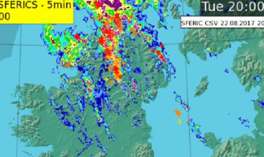
63mm of rain fell in a six hour period at Malin Head on August 22nd. Between 7pm and 9pm, there was 33mm of rainfall was recorded at Ireland’s most northerly point.
“That’s exceptionally high rainfall in any part of Ireland. That’s 16mm in an hour. It’s the intensity of that rainfall that would have been too much for waterways and drainage systems that weren’t adapted to it,” Murphy explained on RTÉ’s News at One.
Climatologists have studied the severe storm and discovered that it is not likely to occur again for 100 years.
Met Eireann issues a yellow weather warning when 25mm is forecast in a 24 hour period, which shows the intensity of the precipitation that struck Donegal yesterday.
An Orange thunderstorm alert was issued across Ireland to warn people to prepare for adverse weather.
In contrast, 30mm fell in the 24 hour period at Finner weather station in south Donegal.
Murphy said thunderstorms converged on the Inishowen Peninsula to create the extremely intense rainfall in a short period.
Hurricane Gert played a part in the mix. Murphy added that moist tropical air from the tail end of the hurricane was sitting over Ireland that reacted with colder air from the west. The intense thunderstorms were sparked by the clash of humid air and cold air.
“The track of the thunderstorms was such that it just seemed to pour relentlessly on the north of the country, especially the Inishowen peninsula,” Murphy said.
This was a once in a lifetime event, as experts say that such conditions have a return period of 100 years in such an isolated area.