


People are being urged to take extra care this Wednesday morning after Storm Ali unleashed torrential rain and severe winds on the north-west overnight.
‘Severe or damaging’ gusts of wind are set to hit Atlantic coastal areas this morning, according to forecasters.
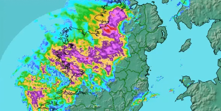
Met Éireann has forecast that the squally showery rain will affect many areas at first, with heavy bursts in places. The rain will clear quickly eastwards later this morning with sunshine and blustery showers.
“Extreme caution is advised in the coastal districts of Clare, Connacht and Donegal this morning,” Met Éireann’s morning notice said.
“South to southwest winds veering westerly will increase to mean speeds between 65 and 80 km/h with gusts between 110 and 120 km/h for a time. The core of strong winds will be along Atlantic Coasts at first and will then move quickly eastwards during the morning.”
The worst of Storm Ali is expected to last until 1pm this Wednesday.
Road users are warned to be on alert in all areas this morning due to the strong winds and relentless rain causing possible spot flooding. The AA Roadwatch has warned that high-sided vehicles are especially vulnerable on open or exposed roads.
“Be particularly mindful of pedestrians, cyclists and motorcyclists. Wind-blown debris is likely to be a problem on secondary roads in particular,” said the road alert newsroom.
A Status Orange Wind Warning is in operation until 1pm for Donegal, before it is eased to a Status Yellow alert until 5pm this Wednesday.
Have you encountered an impassable road this morning? Send your road alerts to info@donegaldaily.com