


 Ex-major hurricane Ophelia will pass to the north of Donegal during today, Thursday, bringing strong to gale force winds to western and northern districts in particular.
The system follows just weeks after the remnants Hurricane Katia saw wind speeds reach 122kp/h at Malin Head.
The UK Met Office has just issued a Yellow Warning for the Six Counties and have advised members of the public to be aware of the risk of disruption to travel plans.
The advisory relates to strong northwesterly gales that will develop during Thursday, particularly around exposed coastal locations and over higher ground. The warning is valid from 10:00 AM to 11:00 PM today, Thursday.
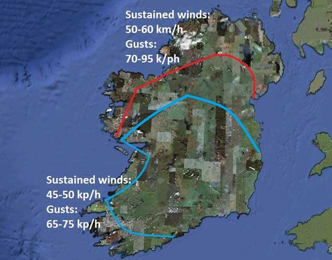
Irishweatheronline.com has reported: “Parts of the northwest also will see winds reaching maximum sustained speeds of 50-60 km/h with higher gusts of 70-95 k/ph. Regions most at risk include west Galway, west Mayo and Donegal.
“The winds will be strong enough to fell trees and cause minor structural damage.
“Winds will not be as strong elsewhere, however. Coastal parts of Clare, Kerry and Cork will see sustained winds of 45-50 kp/h, gusting to 65-75 kph. Conditions will be much calmer inland, with average winds speeds of 30-35 kp/h expected in the Midlands and inland parts of the southeast. On the east Leinster coast, sustained winds will be closer to 40-50 kp/h.”
RTE has issued the following forecast – saying winds will be even higher: “It will be extremely windy on Thursday with the strongest of the west to northwest winds in parts of the north and northwest, where severe gusts of 110 to 120 km/h are likely in exposed areas and coastal regions.”
The site also repeated its forecast of snow over the higher hills of Donegal tonight.
“Windy and cold with passing blustery showers of rain and hail, risk of snow on higher summits mainly northwest, highs 12-15 C with some readings near 10 C mid-day in northwest (sea level), winds WNW 40-60 mph,” it added.
Tags: