The public is being urged to remain vigilant and take care as Storm Brendan tracks across Ireland.
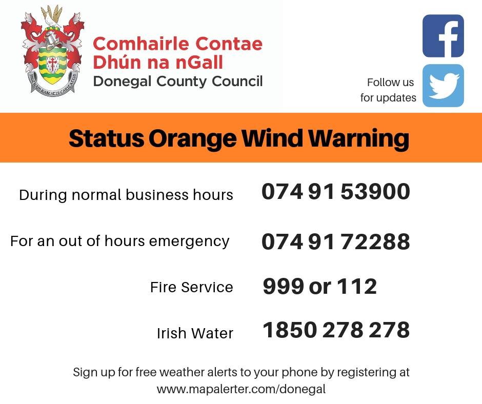
Met Eireann has extended the Status Orange weather warning for Donegal, Galway, Leitrim, Mayo and Sligo until midnight tonight.
The risk of strong damaging winds and coastal flooding remains.
While no coastal flooding has been reported in County Donegal this morning, the indications are that the storm surge will increase again this afternoon and will persist until Wednesday morning with large wave activity possible.
High tide is due at approximately 8.00pm this evening which will be the most vulnerable time for coastal areas.
Clearer conditions, with squally showers of rain and hail, will follow from the west during the afternoon, with the ongoing risk of thunder.
Wind speeds will pick up again this evening however with Mayo and Donegal experiencing very high gusts this evening.
Donegal County Council’s Severe Weather Assessment Team, in conjunction with national agencies; the NDFEM, Met Éireann and the OPW, are continuing to actively monitor the impact of Storm Brendan as it tracks over Ireland today.
A number of trees have fallen across the county and Donegal County Council roads crews are responding to these incidents as they arise.
Roads may be blocked temporarily while these fallen trees are being cleared. The Harry Blaney Bridge linking Carrigart to Fanad is currently closed off to high-sided vehicles.
The following public safety messages are in force:
- Stay away from all coastal areas for the duration of the Met Éireann warnings
- All road users should be aware of the hazardous travelling conditions. Motorists are advised to slow down and be aware of the dangers of fallen trees and debris. High sided vehicles are particularly vulnerable during this time.
- As conditions will vary throughout the day people need to take account of the local conditions and heed any advice from their local authority.